New Delhi | May 18, 2026
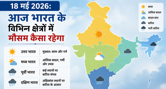
According to the latest meteorological bulletin released by the India Meteorological Department (IMD), the Indian subcontinent is experiencing a striking atmospheric division on Monday, May 18, 2026. While the vast plains of Northern, Central, and Western India remain locked under a punishing, severe heatwave wave, cyclonic pre-monsoon systems are triggering intense thunderstorms and heavy downpours across the southern peninsula and northeastern states. Weather scientists have sounded red and orange alerts across multiple northern states, warning citizens to take extreme precautions during peak daylight hours.
Detailed Weather Forecast for Major Metros and Regions
The localized distribution of temperatures, moisture levels, and wind patterns across the country is structured as follows:
- Delhi-NCR and the Northern Plains: The National Capital Region, alongside the agricultural belts of Punjab, Haryana, and Uttar Pradesh, faces extreme solar radiation. Maximum temperatures are projected to hit record peaks between 45°C and 47°C, while overnight minimums will hover uncomfortably between 32°C and 35°C. High-velocity, scorching surface winds (locally known as Loo) will significantly disrupt outdoor public life.
- Rajasthan, Madhya Pradesh, and Gujarat: This tri-state belt remains the absolute hotspot of the country. Desert zones and central manufacturing districts are recording consistent daytime values between 42°C and 46°C. Regional administrations have activated emergency heatwave response protocols to mitigate the risk of heatstrokes.
- Mumbai and the Western Coast: The financial capital Mumbai and the Konkan coast face a combination of high heat and oppressive humidity. Daily temperatures will range from a maximum of 33°C to 35°C to a minimum of 26°C to 28°C. While heavy coastal moisture will make the air feel thick and sticky, partial cloud cover and localized, transient light drizzles remain highly probable.
- Chennai and Southern India: The pre-monsoon system over the peninsular shelf is operating at peak capacity. Chennai is slated to record a maximum of 36°C to 38°C and a minimum of 27°C to 29°C. Convective cloud developments are expected to bring heavy thunderstorms, lightning, and intense squalls across parts of Tamil Nadu, interior Karnataka, Kerala, and coastal Andhra Pradesh.
- Bengaluru City: The tech hub of Bengaluru continues to enjoy a microclimate that is remarkably pleasant compared to other major metros. The city expects a maximum of 31°C to 33°C and a cool minimum of 21°C to 23°C. Scattered light to moderate evening showers will help maintain comfortable ambient temperatures.
- Kolkata and Eastern/Northeastern India: Kolkata will see a mix of muggy weather and partial cloud layers, with temperatures ranging between 35°C and 37°C. Further east, the IMD has issued severe warnings for the northeastern states—including Assam, Meghalaya, Arunachal Pradesh, and Nagaland—bracing for torrential rainfall and gale-force winds reaching speeds of 40 to 50 km/h.
Primary Atmospheric Catalysts and the Progression of the Monsoon
Climate experts state that the Indian atmosphere is currently shaped by three interacting weather mechanisms. First, dry, continental westerly winds from the northwestern landmass are driving up surface temperatures over the plains. Second, moisture feeds from both the Bay of Bengal and the Arabian Sea are fueling localized cloud generation across southern territories.
The most encouraging developmental update confirms that the Southwest Monsoon currents are tracking smoothly along their historical trajectory. The IMD anticipates that the primary monsoon front will make landfall over the Kerala coast around May 26, laying the groundwork for a phased relief across the rest of the country by the first week of June.
Health and Public Safety Guidelines:
Citizens residing within severe heatwave zones are strongly urged to restrict direct outdoor exposure between 12:00 PM and 4:00 PM. To combat dehydration, maintain regular fluid consumption, use loose, light-colored cotton apparel, and utilize oral rehydration salts (ORS), fresh lime water, or balanced electrolyte formulations. Conversely, travelers in the northeastern and southern belts should secure safe indoor shelter during thunder activities, keeping a safe distance from high-voltage transmission lines and weak trees.
Disclaimer: This regional meteorological analysis is compiled for public information and general awareness purposes. The specific temperature indices, atmospheric models, and safety alerts are derived from satellite imagery and diagnostic bulletins published by the India Meteorological Department (IMD) on May 18, 2026. Because local micro-climatic networks are subject to sudden transitions, individuals are advised to check live radar feeds on the official IMD portal or their authorized ‘Mausam’ application prior to finalizing transport schedules, agricultural logistics, or outdoor events.
To read this news in Hindi, click here: missionkiawaaz.in